 http://www.ocarto.com/?zoom=4&location=&locationLat=&locationLng=&lat=45.336701909968106&lng=-106.875&w=800&h=600&topBar=1&map1=tmap_t&#
Thursday, January 31, 2008
USA topographic map
Topographic map of United States.
 http://www.ocarto.com/?zoom=4&location=&locationLat=&locationLng=&lat=45.336701909968106&lng=-106.875&w=800&h=600&topBar=1&map1=tmap_t&#
http://www.ocarto.com/?zoom=4&location=&locationLat=&locationLng=&lat=45.336701909968106&lng=-106.875&w=800&h=600&topBar=1&map1=tmap_t&#
Sunday, January 27, 2008
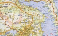
Finland road map
Road map of Finland in sheets.

Road transport in Finland is the most popular method of transportation, particularly in rural areas where the railway network does not extend to. As of 2011 there are 78,162 kilometres of public roads, of which 51,016 kilometres are paved. The main road network comprises over 13,329 kilometres of road. (wp)
Monday, January 21, 2008


Friday, January 18, 2008

Wednesday, January 16, 2008

Tuesday, January 15, 2008

Wednesday, January 9, 2008

Monday, January 7, 2008

Thursday, January 3, 2008
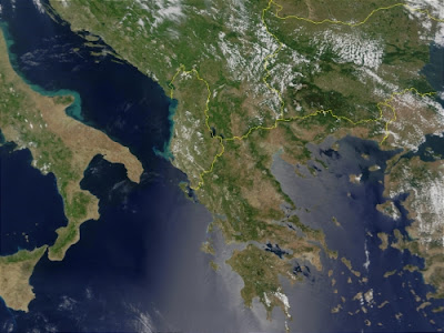
Greece satellite image
Satellite image of Greece.
This true-color image acquired from MODIS on June 6, 2001, shows Greece along with its neighboring countries: Italy, Albania, Macedonia, and Turkey, from left to right respectively.
 http://visibleearth.nasa.gov/view_rec.php?id=1982
More maps of Greece
This true-color image acquired from MODIS on June 6, 2001, shows Greece along with its neighboring countries: Italy, Albania, Macedonia, and Turkey, from left to right respectively.
 http://visibleearth.nasa.gov/view_rec.php?id=1982
Subscribe to:
Posts (Atom)