 |
| Click to enlarge |
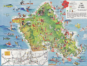
Map from "Honolulu Handy Guide," published by Tongg Publishing, 1978.
Geography, cartography, news on maps, online maps and route planners from around the world.
 |
| Click to enlarge |
 |
| Click to enlarge |
 |
| Click to enlarge |
 |
| Click to enlarge |
The political alignments of the world are here shown, centering geographically around the North Pole but ideologically and economically around the U.S. The classification keyed below is necessarily simplified and does not of course meet all the subtleties of politics and diplomacy - for instance, the peculiar position of Vichy and its colonies. The special case of the U.S.S.R. is acknowledged by a special color.
The situation is as of July 7, 1941, and is subject to change without notice.Map made by Richard Edes Harrison, Fortune magazine.
Earth’s city lights is a composite assembled from data acquired by the Suomi NPP satellite. The data was acquired over nine days in April 2012 and 13 days in October 2012. It took 312 orbits to get a clear shot of every parcel of Earth's land surface and islands. (Source: Nasa)
 |
| Composite map of the world assembled from data acquired by the Suomi NPP satellite in April and October 2012. |
 |
| Twitter/Avaaz |
 |
| Twitter/Caabu |