 |
| World |
Geography, cartography, news on maps, online maps and route planners from around the world.
Monday, December 8, 2014
The Cedid Atlas, 1803
The Cedid Atlas is the first comprehensive atlas compiled by the Ottoman Empire and published in Istanbul in 1803.
Monday, November 10, 2014
Wednesday, November 5, 2014
Tuesday, November 4, 2014
Most popular on MapsOnTheWeb, October 2014
Most popular posts on MOTW based on the number of tumblr notes, excluding reblogs.
- Old World Language Families Map - 6,647 notes
- Map of Yellowstone Park drawn as a bear - 4,062 notes
- Countries that recognize the state of Palestine, 2014 - 2,941 notes
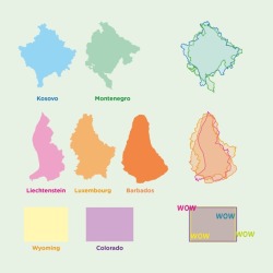
- Countries that look like other countries, with bonus wow content - 1,954 notes

- Average Number of Languages Spoken by the EU Population - 1,806 notes
- The World in Words - 1,641 notes
- The longest distance you can travel between two points in straight line without crossing any ocean or any major water bodies - 1393 notes
- Consumption of milk around the world, 2007 - 1,353 notes
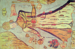
- 16th century map depicting Europe as a queen - 1,172 notes

- Wildlife of Scotland - 933 notes
- Outcome Of The 2012 US Presidential Election If Only White Men Could Vote - 911 notes
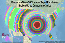
- U.S. States of Equal Population, by Concentric Circles - 875 notes

- Urban Sprawl: Two Orlando houses with adjacent backyards are separated by 7 miles of roads - 835 notes
- Europe in 800 AD - 833 notes
- The world’s main biomes - 773 notes
- Eyes and hair color in Europe - 627 notes
- If the US were two states of equal population - 623 notes
Thursday, October 23, 2014
Longest Straight Lines Without Crossing Coasts
The longest distance you can travel between two points in straight line without crossing any ocean or any major water bodies:
Tuesday, October 14, 2014
Tuesday, October 7, 2014
Most popular on MapsOnTheWeb, September 2014
Most popular posts on MOTW based on the number of tumblr notes, excluding reblogs.
- How Africa Would Look Like if its Borders Were Defined By Ethnicity and Language - 17,154 notes
- Countries with less population than PewDiePie’s subscribers - 10,793 notes
- Prevalence of “um” vs. “uh” in the United States - 8801 notes
- Favorite music artist by US state - 4037 notes
- Which country last (successfully) invaded you? (Europe) - 3995 notes
- Literary map of London - 3071 notes
- Every country that has declared independence from the U.K./Great Britain - 1917 notes
- What 16th Century Ottomans thought Europe looked like on Top of an Actual Map of Europe - 1553 notes
- Geographic and demographic changes to UK if Scotland secedes - 1415 ntoes
- Countries bombed by the United States of America in the 21st century - 1402 notes
- Linguistic map of Europe with flags representing each language - 1249 notes
- Origins of Historical Figures in Europe from 1600 to 1800 by type of contribution - 1156 notes
- Colours of passports around the world - 1139 notes
- Europe in 1000 A.D. - 821 notes
- Watersheds in the United States - 731 notes
- Relative size of Africa using Gall-Peters projection - 724 notes
- Apple is richer than all these countries - 676 notes
- Languages and dialects of Europe - 657 notes
- What Germany is called in different European languages - 654 notes
- Expansion of the city of Paris from 300 A.D to 1850 A.D - 651 notes
- The rail map of Australia - 634 notes
- From where countries import the most? - 600 notes
- Dubbing in Europe - 582 notes
- World map from 1662 - 579 notes
- World Median Ages - 577 notes
- France by French - 570 notes
- Tenochtitlan, capital of the Aztec Empire and what became Mexico City, in pre-Columbian America - 559 notes
- Support (in blue) or Opposition (in red) to Scottish Independence - 550 notes
- Cold War Alliances - 542 notes
- Presidents and prime ministers of Europe - 538 notes
- Map of each U.S. States Favorite Foods - 524 notes
- European Revue - Kill That Eagle. A satirical map of the war in 1914 - 519 notes
- Map of Titan, the largest moon of Saturn - 508 notes
- Writing systems of the world - 491 notes
- Stereotypes of Vatican City - 488 notes
Sunday, September 28, 2014
Thursday, September 18, 2014
Thursday, September 4, 2014
Salar de Uyuni Map
Road network near Salar de Uyuni and Salar de Coipasa, Bolivia.
Click to enlarge
Salar de Uyuni (or Salar de Tunupa) is the world's largest salt flat at 10,582 square kilometers (4,086 sq mi). It is located in the Potosí and Oruro departments in southwest Bolivia, near the crest of the Andes and is at an elevation of 3,656 meters (11,995 ft) above mean sea level. (wikipedia)Source: Instituto Geográfico Militar
Thursday, July 24, 2014
CompareMaps: Comparing major map providers
CompareMaps is a great tool for comparing differences between major map providers like Google Maps, OpenStreetMaps, Bing Maps and Nokia Here Maps.
Monday, July 14, 2014
Online Mapping Tools
This list is no longer maintained. For an updated list click here.
A list with online tools and libraries for creating interactive or static maps.
A list with online tools and libraries for creating interactive or static maps.
Saturday, June 14, 2014
Tuesday, May 20, 2014
Top 20 football stadiums in the world
The 20 biggest football stadiums in the world, on a single infographic.


preview
Thursday, April 17, 2014
Wednesday, April 9, 2014
Tuesday, March 4, 2014
Wednesday, February 26, 2014
Departments of Bolivia
Bolivia is divided into nine departments (Spanish: departamentos). Each of the departments is subdivided into provinces (provincias), which are further subdivided into municipalities (municipios).
Saturday, February 8, 2014
French Colonial Empire, 1931
Colonial Empire of France in 1931.
Blue - French territories, Red - English territories
published by Fortune Magazine, via
Click to enlarge
Blue - French territories, Red - English territories
published by Fortune Magazine, via


