 http://ranu.wordpress.com/2007/10/04/peta-mudik-2007/
Friday, November 26, 2010
Monday, November 15, 2010

Tuesday, August 31, 2010

Monday, August 9, 2010
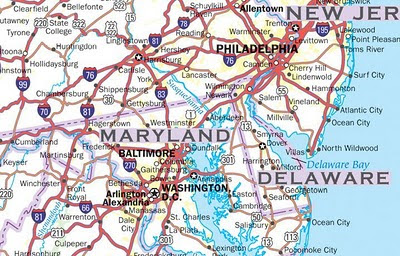
United States Highways
United States Highway Map including: State Capitals, Cities, US Interstates (numbered), US Highways (numbered), Major Freeways, Highways, and Toll Roads, Major Lakes & Rivers, Time Zones, Insets of Hawaii and Alaska .
 http://usa.zoom-maps.com/
http://usa.zoom-maps.com/
Wednesday, August 4, 2010
Bulgaria road map
Interactive road map of Bulgaria.
National Parks and Monuments • Points of Interest • Tourist Attractions, Resorts and Facilities • Road Distances • Street map of Sofija, Plovdiv, Burgas and Varna • Detailed Scale of: 1:800,000
 http://bulgaria.zoom-maps.com/
National Parks and Monuments • Points of Interest • Tourist Attractions, Resorts and Facilities • Road Distances • Street map of Sofija, Plovdiv, Burgas and Varna • Detailed Scale of: 1:800,000
http://bulgaria.zoom-maps.com/
Sunday, July 25, 2010

Wednesday, July 21, 2010
Europe river basins
International river basins of Europe.

Click on preview
Zoomable road map of Europe with relief and distances.
 http://europe.zoom-maps.com/

Zoomable road map of Europe with relief and distances.
http://europe.zoom-maps.com/
Tuesday, July 20, 2010
China administrative divisions
Administrative divisions of China labeled as countries with equivalent populations.

Click on preview

Monday, July 19, 2010
Territorial changes of Iran
Territorial changes of Persia and Iran in th 19th and 20th centuries.

Click on the preview

Monday, June 28, 2010
Thursday, June 24, 2010
North Korean Prison Camps
North Korea has operated political prison camps for more than 50 years, twice as long as the Gulag in the former Soviet Union. People suspected of opposing the government are forced to do slave labor in the camps, which hold an estimated 200,000 prisoners. North Korea's government says the camps don't exist, but high-resolution satellite images show otherwise.
 http://www.washingtonpost.com/wp-srv/special/world/north-korean-prison-camps-2009/
http://www.washingtonpost.com/wp-srv/special/world/north-korean-prison-camps-2009/
Tuesday, June 22, 2010

Monday, June 21, 2010
Monday, June 14, 2010

Monday, June 7, 2010

Wednesday, June 2, 2010

Sunday, April 4, 2010

Saturday, April 3, 2010

Thursday, March 25, 2010
Finland topographic map
Interactive topographic map of Finland.

Finland is the northernmost country on the European continent. Although other countries have points extending north, virtually all of Finland is north of 60 degrees north latitude; nearly a quarter of the land area and fully one-third of the latitudinal extent of the country lie north of the Arctic Circle. (wp)
Tuesday, March 16, 2010
The Andes Travel Map
Travel map of Western South America and The Andes. Detailed maps: Cusco/Machu Picchu, Santiago. City maps: Central Bogotá, Quito, La Paz, Central Lima, Arica, Iquique, Antofagasta, La Serena, Central Santiago.
 http://andes.zoom-maps.com/
http://andes.zoom-maps.com/Monday, March 15, 2010
Tierra del Fuego maps
Travel map of Western South America and The Andes including Tierra del Fuego.
http://andes.zoom-maps.com/
http://andes.zoom-maps.com/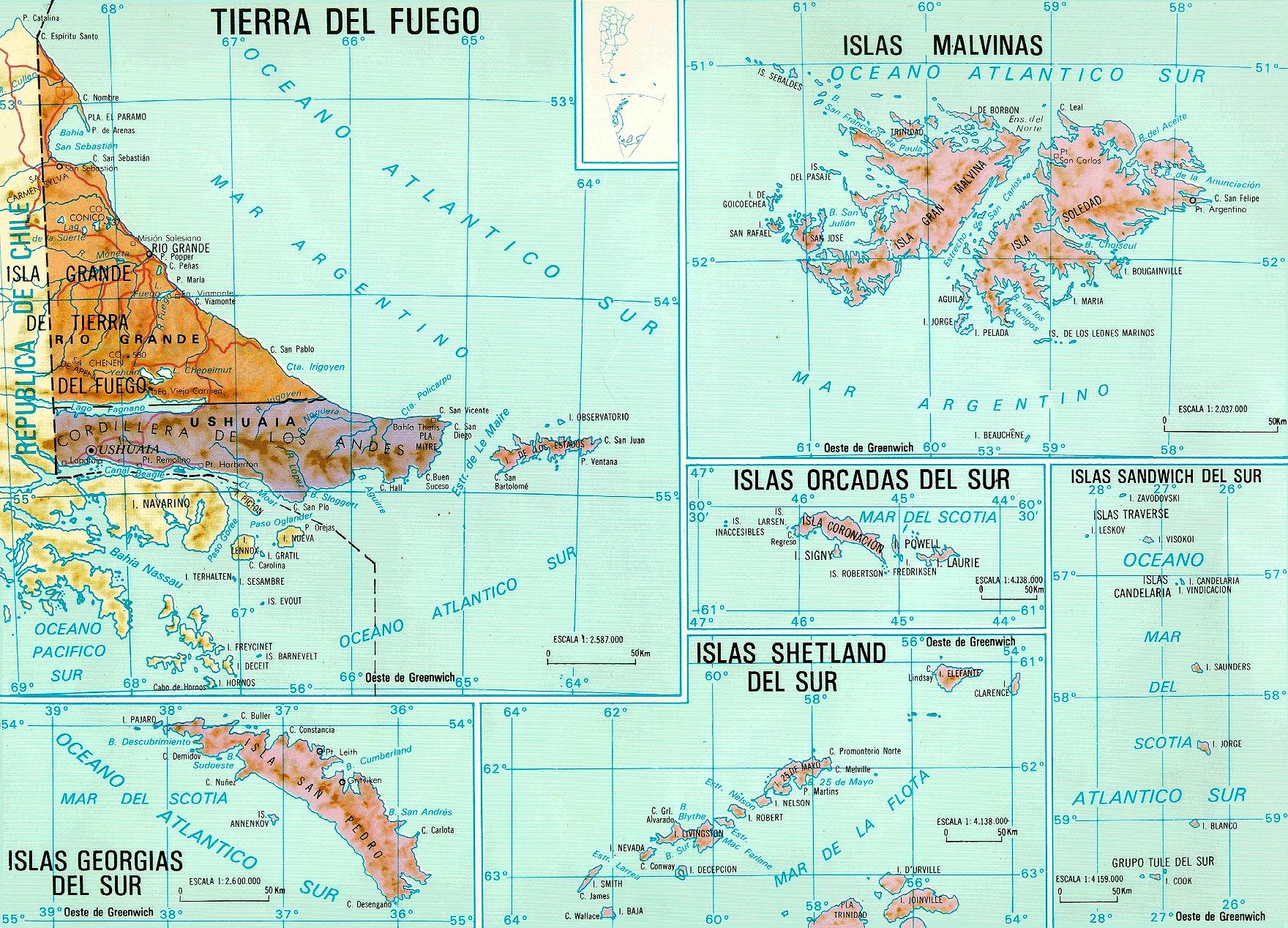 |  |
 |  |
Thursday, March 11, 2010


Monday, March 1, 2010


Monday, February 8, 2010

Sunday, January 24, 2010
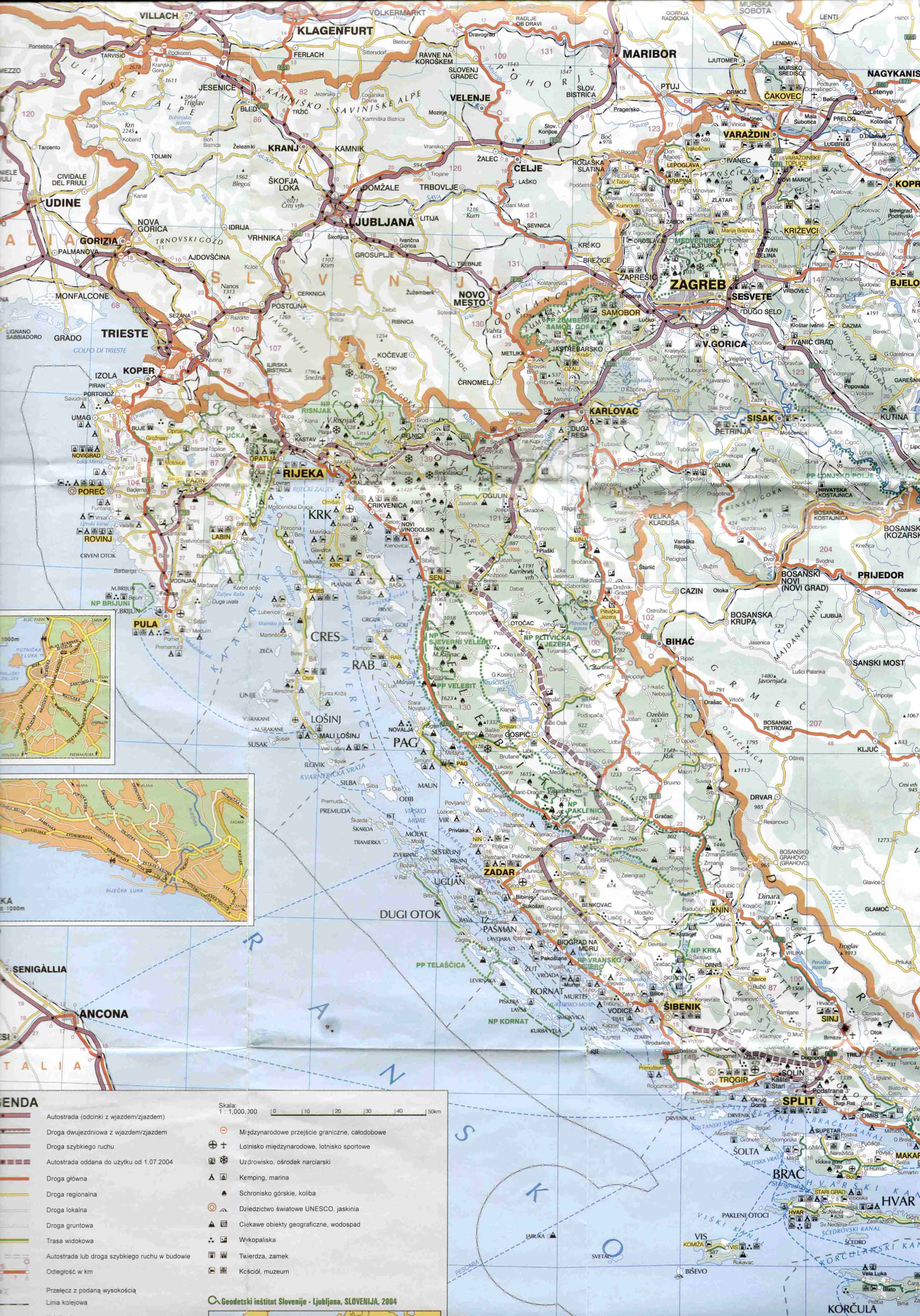
Montenegro relief map
Topographic and relief map of Montenegro.
 http://www.bjelasica-komovi.com/files/maps/Montenegro_map.jpg
 http://www.bjelasica-komovi.com/files/maps/Montenegro_map.jpg
Sunday, January 17, 2010

Friday, January 15, 2010
Haiti political map
Map of Haiti with administrative divisions and shaded relief.
 http://www.quid.fr/monde.html?mode=detail&iso=ht&style=carte&zoom=2&id=50261&docid=2840
http://www.quid.fr/monde.html?mode=detail&iso=ht&style=carte&zoom=2&id=50261&docid=2840
Tuesday, January 12, 2010
Suriname physical map
Physical map of Suriname with administrative divisions.
 http://www.gimitori.net/img/kaart%20suriname.jpg
 http://www.gimitori.net/img/kaart%20suriname.jpg
Monday, January 11, 2010

Subscribe to:
Comments (Atom)