Online Maps

Geography, cartography, news on maps, online maps and route planners from around the world.

Monday, November 10, 2014

South Dakota County Map

Counties of South Dakota.


Posted at: 1:11 PM 0 comments
Email ThisBlogThis!Share to XShare to FacebookShare to Pinterest
Labels: county map, South Dakota

Wednesday, November 5, 2014

Bolivia vegetation

 Vegetation in Bolivia.

Posted at: 12:42 PM 0 comments
Email ThisBlogThis!Share to XShare to FacebookShare to Pinterest
Labels: Bolivia, vegetation map

Tuesday, November 4, 2014

Most popular on MapsOnTheWeb, October 2014

Most popular posts on MOTW based on the number of tumblr notes, excluding reblogs.
  • Old World Language Families Map - 6,647 notes
  • Map of Yellowstone Park drawn as a bear - 4,062 notes
  • Countries that recognize the state of Palestine, 2014 - 2,941 notes
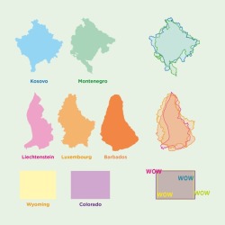
  • Countries that look like other countries, with bonus wow content - 1,954 notes

    http://33.media.tumblr.com/5bd5262378f506206337c3a6080d6dd4/tumblr_ndiitiMDBw1rasnq9o1_250.jpg
  • Average Number of Languages Spoken by the EU Population - 1,806 notes
  • The World in Words - 1,641 notes
  • The longest distance you can travel between two points in straight line without crossing any ocean or any major water bodies - 1393 notes
  • Consumption of milk around the world, 2007 - 1,353 notes
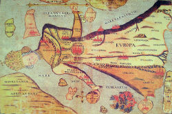
  • 16th century map depicting Europe as a queen - 1,172 notes

    http://40.media.tumblr.com/eecdb03a7696e13219118ad192a843e3/tumblr_ncrbo529ks1rasnq9o1_250.jpg
  • Wildlife of Scotland - 933 notes
  • Outcome Of The 2012 US Presidential Election If Only White Men Could Vote - 911 notes
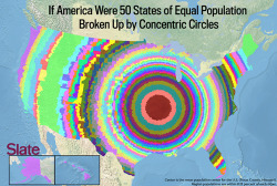
  • U.S. States of Equal Population, by Concentric Circles - 875 notes

    http://33.media.tumblr.com/8070f89f010103131c6389b9af69a617/tumblr_nd27b110kQ1rasnq9o1_250.png
  • Urban Sprawl: Two Orlando houses with adjacent backyards are separated by 7 miles of roads - 835 notes
  • Europe in 800 AD - 833 notes
  • The world’s main biomes - 773 notes
  • Eyes and hair color in Europe - 627 notes
  • If the US were two states of equal population - 623 notes
Posted at: 11:01 AM 0 comments
Email ThisBlogThis!Share to XShare to FacebookShare to Pinterest
Labels: motw
Newer Posts Older Posts Home
Subscribe to: Posts (Atom)

Share this page

Tweet

Follow Us

onlmaps twitter onlmaps facebook onlmaps google plus onlmaps tumblr

RSS

Posts
Atom
Posts
All Comments
Atom
All Comments

Blog Archive

  • ►  2015 (4)
    • ►  March (2)
    • ►  February (2)
  • ▼  2014 (19)
    • ►  December (1)
    • ▼  November (3)
      • South Dakota County Map
      • Bolivia vegetation
      • Most popular on MapsOnTheWeb, October 2014
    • ►  October (3)
    • ►  September (3)
    • ►  July (2)
    • ►  June (1)
    • ►  May (1)
    • ►  April (2)
    • ►  March (1)
    • ►  February (2)
  • ►  2013 (65)
    • ►  December (2)
    • ►  November (2)
    • ►  October (4)
    • ►  September (2)
    • ►  August (1)
    • ►  July (4)
    • ►  June (6)
    • ►  May (10)
    • ►  April (7)
    • ►  March (3)
    • ►  February (7)
    • ►  January (17)
  • ►  2012 (193)
    • ►  December (11)
    • ►  November (6)
    • ►  October (11)
    • ►  September (30)
    • ►  August (32)
    • ►  July (21)
    • ►  June (6)
    • ►  May (20)
    • ►  April (27)
    • ►  March (25)
    • ►  February (4)
  • ►  2011 (26)
    • ►  December (3)
    • ►  November (5)
    • ►  October (11)
    • ►  September (2)
    • ►  July (2)
    • ►  June (1)
    • ►  March (2)
  • ►  2010 (29)
    • ►  November (2)
    • ►  August (3)
    • ►  July (4)
    • ►  June (7)
    • ►  April (2)
    • ►  March (5)
    • ►  February (1)
    • ►  January (5)
  • ►  2009 (78)
    • ►  December (6)
    • ►  November (5)
    • ►  October (14)
    • ►  September (15)
    • ►  August (5)
    • ►  July (6)
    • ►  June (6)
    • ►  May (3)
    • ►  April (4)
    • ►  March (2)
    • ►  February (4)
    • ►  January (8)
  • ►  2008 (33)
    • ►  December (2)
    • ►  November (7)
    • ►  October (2)
    • ►  September (1)
    • ►  August (1)
    • ►  July (2)
    • ►  April (1)
    • ►  March (1)
    • ►  February (7)
    • ►  January (9)
  • ►  2007 (23)
    • ►  December (12)
    • ►  November (11)

Popular Posts

  • Africa country map
    Political map of Africa. Click to enlarge Interactive political map of Africa with shaded relief. http://africa.zoom-maps.com/ ...
  • Map of England with Counties
    Counties of England. England, formerly a kingdom and independent country, united with Scotland to form what would eventually become the UK...
  • Africa map with capitals
    Political map of Africa with capitals and major cities. With over 800 million human inhabitants in 54 countries, it accounts for about one s...
NetworkedBlogs
Blog:
Online Maps
Topics:
Maps, Travel, Guides
 
Follow my blog

Online Marketing
Add blog to our directory.
  • Privacy Policy

Labels

administrative divisions (2) Afghanistan (2) Africa (11) Alabama (2) Alaska (1) Algeria (4) Alps (1) Amazon (1) Andes (1) Angola (2) Antarctica (2) apple (1) Aral Sea (1) Arctic (4) Argentina (3) Arizona (1) Arkansas (2) Armenia (1) Asia (11) asteroid (1) astronomy (1) Atlantic Ocean (1) Australia (13) Austria (4) Azerbaijan (1) Bangladesh (1) Barbados (1) Belarus (1) Belgium (2) Belize (1) Bermuda (1) blank map (12) Bolivia (5) borders (1) Bosnia Herzegovina (1) Boston (2) Brazil (2) Brunei (1) Bulgaria (3) Burundi (1) California (5) Cambodia (1) Cameroon (1) Canada (10) Central Africa (1) Central America (6) Chad (1) Chicago (2) Chile (4) China (12) climate map (7) Colombia (2) Colorado (2) compare (5) Connecticut (1) Costa Rica (1) county map (49) Crater Lake (1) Croatia (2) Cuba (1) Cyprus (2) Czech Republic (1) D.R.Congo (1) Denmark (2) dispute (1) Dominican Republic (1) earthquake (1) East Coast (1) East Timor (1) economy (9) Ecuador (4) Egypt (5) El Salvador (1) England (5) Estonia (2) Ethiopia (1) Europe (30) European Union (1) fail (6) Finland (2) Florida (4) France (7) French Guiana (1) gdp (2) general map (1) geological map (1) Georgia (1) Germany (9) Ghana (1) google maps (2) Grand Canyon (1) Great Britain (2) Great Salt Lake (1) Greece (2) Greenland (2) Guatemala (2) Gulf of Mexico (1) Gulf Stream (1) Guyana (1) Haiti (2) Harris County (1) Hawaii (3) historical map (4) history (15) Honduras (1) Hong Kong (1) Houston (1) Hudson Bay (1) Hungary (4) Iceland (2) Idaho (1) Illinois (3) India (3) Indiana (1) Indonesia (3) infographic (7) interactive map (18) Iowa (1) Iran (2) Iraq (2) Ireland (5) isometric map (1) Israel (6) Istanbul (1) Italy (4) Jamaica (1) Japan (4) Jordan (2) Kansas (2) Kazakhstan (1) Kentucky (2) Kenya (1) Kosovo (1) Kuwait (1) lake map (4) Lake Ozarks (1) Lake Tahoe (1) Laos (2) Latin America (5) Lebanon (3) Lesotho (1) Libya (4) linguistic map (1) London (3) Los Angeles (1) Louisiana (1) Luxembourg (1) Madagascar (1) Maine (2) Malawi (1) Malaysia (2) Mali (2) Malta (1) Manhattan (1) map collections (1) Maryland (1) Massachusetts (2) Mediterranean (1) metro map (1) Mexico (1) Michigan (1) Middle East (7) Minnesota (1) Mississippi (2) Missouri (2) Mongolia (1) Montana (1) Montenegro (2) Morocco (1) Morroco (1) motw (2) Mount Everest (1) Mozambique (1) Myanmar (2) NASA (2) Nebraska (2) Nepal (4) Netherlands (5) Nevada (1) New England (1) New Hampshire (3) New Jersey (1) New Mexico (2) New York (7) New Zealand (2) Nicaragua (1) Nigeria (1) North America (8) North Carolina (1) North Colorado (1) North Dakota (1) North Korea (3) Northern Ireland (1) Norway (2) nuclear weapons (3) Oahu (1) Oceania (1) Ohio (1) Okeechobee (1) Oklahoma (1) old map (16) Oman (2) Oregon (2) Pakistan (4) Palestine (2) Panama (3) Papua New Guinea (1) Paris (1) Pennsylvania (2) Peru (2) Philippines (2) physical map (66) Poland (3) political map (34) population density (1) Portugal (3) postcard (12) projections (1) Puerto Rico (3) puzzle (1) rail map (2) real-time (1) relief map (36) religious map (3) Rhode Island (3) roadmap (64) Romania (4) route planner (6) Russia (3) Rwanda (1) Sahara (1) Salt Lake City (1) San Francisco (2) satellite image (10) Saudi Arabia (2) Scotland (4) sea level (1) seismic map (2) Serbia (2) Singapore (1) Slovakia (1) Slovenia (2) South Africa (2) South America (14) South Australia (1) South Carolina (1) South Dakota (1) South Korea (2) South Sudan (1) Soviet Union (2) space (6) Spain (4) sports (1) Sri Lanka (2) state map (3) subway map (1) Sudan (1) Suriname (2) Swaziland (1) Sweden (3) Switzerland (3) Syria (2) Taiwan (2) Tanzania (2) Tennessee (2) Texas (3) Thailand (1) thematic map (31) Thüringen (1) time zones (1) tools (2) topographic map (8) tourist map (6) traffic (1) transportaion map (1) Turkey (4) Turkmenistan (1) Uganda (2) Ukraine (2) United Arab Emirates (1) United Kingdom (11) United States (29) Uruguay (1) Utah (3) vegetation map (2) Venezuela (1) Venus (1) Vermont (3) Vietnam (1) Virginia (2) Wales (1) war (3) Washington (1) weather map (4) West Virginia (1) Western Australia (1) Western Europe (3) Western Sahara (1) wikipedia (1) Wisconsin (1) world atlas (4) world map (30) world war 2 (3) Wyoming (1) Yemen (2)
Online Maps
Free maps from around the world
Travel Blogs - BlogCatalog Blog Directory Online Maps
Powered by Blogger.