Showing posts with label Canada. Show all posts

Saturday, January 12, 2013

St. Lawrence River Map

Map of Saint Lawrence River basin.
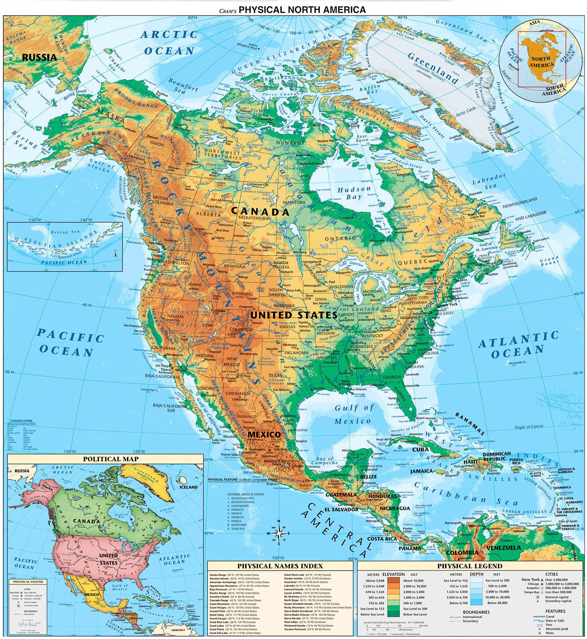
The Saint Lawrence is a large river flowing approximately from southwest to northeast in the middle latitudes of North America, connecting the Great Lakes with the Atlantic Ocean. (wp)
Click to enlarge

Wednesday, January 2, 2013

Canada, 19th century

Provinces and territories of Canada at the end of the 19th century.

Click to enlarge

Tuesday, July 17, 2012

Eastern Canada Map

Physical map of Eastern Canada with major cities, geographical features and shaded relief. Canada is the world's second-largest country in total area (after Russia), but has a low population density with just 32 million inhabitants (Canadians). This is a small number for a country of this size. For example, Canada covers a larger geographic area than the United States, but has only a ninth the population.

Click to enlarge

Friday, May 4, 2012

Canada States Map

Map of administrative divisions of Canada. Canada consists of ten provinces and three territories. The major difference between a Canadian province and a Canadian territory is that a province is a creation of the Constitution Act, while a territory is created by federal law. 

Click to enlarge

Saturday, April 14, 2012

Blank Canada Map

Blank map of Canada with administrative divisions.

Click to enlarge

Monday, October 24, 2011

East Coast Map

Physical map of East Coast of the United States and Canada.

Click to enlarge

Wednesday, November 19, 2008

North America physical map

North and Central America physical map, including the United States and Canada, shows the variety of land elevations on the continent.

Click to enlarge

United States Highway Map including: State Capitals, Cities, US Interstates (numbered), US Highways (numbered), Major Freeways, Highways, and Toll Roads, Major Lakes & Rivers, Time Zones, Insets of Hawaii and Alaska .

http://usa.zoom-maps.com/

Wednesday, November 14, 2007

Canada topographic map

Topographical maps of Canada. The maps depict, in detail, ground relief (landforms and terrain), drainage (lakes and rivers), forest cover, administrative areas, populated areas, transportation routes and facilities (including roads and railways), and other constructed features. The maps show data from the 1:250 000 and 1:50 000 National Topographic Databases.

http://atlas.nrcan.gc.ca/site/english/maps/topo/map