 |
| Click to enlarge |
Thursday, May 10, 2012
UK Physical Map
Physical map of the United Kingdom. The United Kingdom of Great Britain and Northern Ireland comprises Great Britain (England, Scotland and Wales) and Northern Ireland.
Asia and Europe Map
Physical map of Eurasia. Eurasia refers to the combined land mass of Europe and Asia. Eurasia is alternatively considered to be a continent, or a supercontinent composed of the continents of Europe and Asia.
 |
| Click to enlarge |
Wednesday, May 9, 2012
Western Europe Geological Map
Geological map of Western and Central Europe. The Geology of Europe is hugely varied and complex, and gives rise to the wide variety of landscapes found across the continent, from the Scottish Highlands to the rolling plains of Hungary.
 |
| Click to enlarge |

Tuesday, May 8, 2012
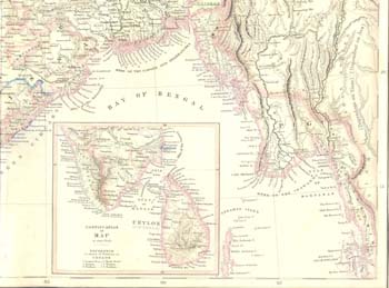
Old physical map of South Asia
This is an old physical map of South Asia from 'Companion Atlas to the Gazetteer of the World', published by A. Fullarton, Edinburgh, 1859. Four sheets.
New Jersey County Map
Counties of New Jersey. New Jersey is a state of the United States and its U.S. postal abbreviation is NJ. New Jersey was named after the island of Jersey in the English Channel.
 |
| Click to enlarge |
Monday, May 7, 2012
West Virginia County Map
Counties of West Virginia. West Virginia is a state of the United States, known as The Mountain State.
 |
| Click to enlarge |
Blank Map of Latin America
Blank map of Latin America. The term Latin America is used loosely to refer to all the American countries south of the United States.
| Click to enlarge |
Washington County Map
Counties of Washington State. Washington is a state located in the northwestern United States. It should not be confused with Washington, D.C., the capital of the USA. While the state capital is Olympia, the largest city in Washington is Seattle.
 |
| Click to enlarge |
Saturday, May 5, 2012
Houston Area Map
Map of Houston and its neighborhoods. Located in southeast Texas, Houston is the fourth largest city in the United States and one of the two largest economic areas in Texas. (Wikipedia)
 |
| Click to enlarge |
Friday, May 4, 2012
Nevada County Map
Counties of Nevada. Nevada is a state located in the western United States. The population of the state, as of 2000, is 1,998,257. Nevada is one of the fastest growing states in the country.
 |
| Click to enlarge |
Canada States Map
Map of administrative divisions of Canada. Canada consists of ten provinces and three territories. The major difference between a Canadian province and a Canadian territory is that a province is a creation of the Constitution Act, while a territory is created by federal law.
 |
| Click to enlarge |
Thursday, May 3, 2012
Blank map of the continents
Blank map of the continents with country borders and geographic coordinate system. A continent is a large continuous mass of land.
| Click to enlarge |
Gulf Stream Map
Map of the Gulf Steram. The Gulf Stream is a powerful warm, swift Atlantic ocean current that flows along the coast of the Eastern United States and makes Ireland, Great Britain, and the Scandinavian countries warmer than they would be otherwise.
 |
| Click to enlarge |
Wednesday, May 2, 2012
Salt Lake City Area Map
Salt Lake City area map. Salt Lake City is the capital of Utah, a state of the United States of America.


Utah County Map
Counties of Utah. Utah is a western state of the United States, in the Rocky Mountains region.


East Asia physical map
Physical map of East Asia. The continent of Asia is defined by subtracting Europe and Africa from the great land mass of Africa-Eurasia.
 |
| Click to enlarge |
Tuesday, May 1, 2012
Countries with greatest risk of terrorism
An infographic of countries with greatest risk of terrorism based on data released by British analysis company Maplecroft and published in the 2011 Terrorism Risk Index.

Oregon County Map
County map of Oregon. Oregon is a state located in the western United States bordering the Pacific Ocean, California, Washington, Idaho, and Nevada. Its northern border lies along the Columbia River and the east along the Snake River.


Northeastern United States Map
Map of Northeastern United States with states, cities, and main roads. The region comprises nine states: the New England states of Connecticut, Maine, Massachusetts, New Hampshire, Rhode Island and Vermont; and the Mid-Atlantic states of New Jersey, New York and Pennsylvania. (Wikipedia)
 |
| Click to enlarge |
Subscribe to:
Posts (Atom)